Tsi nityothyonhí:non “Where the River Originates”
Goulding Miikaans/Goulding Epngishmok
Location
GPS Coordinates
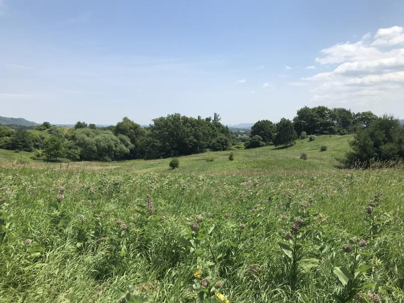
Goulding West is a 32-hectaire nature reserve situated at the end of Goulding Lane, in the township of Mono, north of Caledon, and in Dufferin County. This location sits within the Niagara Escarpment Plan boundary and is part of a geographic region that serves as headwaters for a number of important rivers in southern Ontario, including the Humber, Nottawasaga, and Grand Rivers. The property was formerly farmland that was used for pasture and as hayfields but has been retired and is currently managed by the Nature Conservancy of Canada.
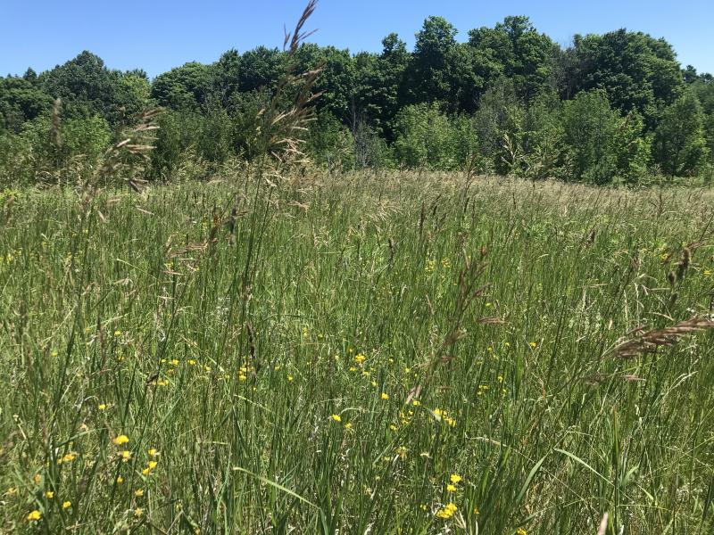
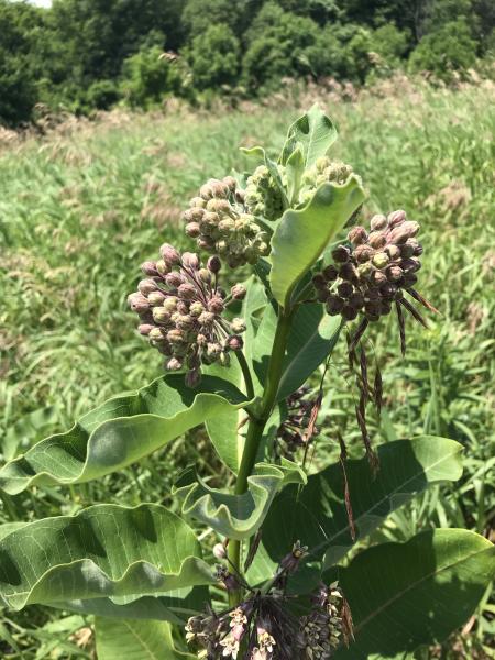
Composed of grassy meadows interspersed with patchy thickets and tree saplings, Goulding West represents an early successional plant community following agricultural abandonment, which is common in the countryside of southern Ontario. Smooth brome is the dominant grass cover, which co-occurs with rye-brome, timothy, orchard grass, Kentucky bluegrass, and flattened meadow-grass. These grass species are closely associated with agricultural land-use. However, there have been recent efforts to plant native prairie grass species, such as big bluestem and Virginia wild rye. These meadows are also home to wildflowers, including native asters, goldenrods, and milkweed, as well as introduced species such as buttercups, hawkweeds and goat’s beard, wild carrot, bedstraws, clovers and vetches. Tree regeneration consists of green ash and Scots pine, which are often draped with grapevines.
Additionally, a mature sugar maple woodlot sits on the northeast corner, and lines of mature maple trees border the Goulding West property. These lines of trees are the remnants of agricultural shelterbelts, which, in agro-ecosystems, play important ecological roles including slowing down wind and retaining soil moisture, which prevents soil erosion, and providing habitat for animals such as songbirds, insects, and rodents.
Dufferin County and the Humber headwaters region has at least a 13,000-year history of human habitation. In nearby Caledon, excavations of findspots and campsites dating from what archaeologists call the Paleoindian (12,000 – 10,000 BC) through the Archaic (11,500 to 3,200 BC) periods suggest that, during these time periods, the peoples that lived in this area had small-scale settlements that they shifted due to seasons (“nomadic” or “semi-nomadic”), and their economies and lifeways centered on wild harvesting of plants, animals, and fish in family or small extended family groups. Archaeologists have excavated copper artifacts in Dufferin county, including nearby Melanchthon township, that date from the Archaic period, whose source materials originate from north of Lake Superior, which indicates that these ancient peoples had long-distance trade networks or traveled extensively themselves. It is likely that these ancient inhabitants of the Humber headwaters from Paleoindian and Archaic periods were the ancestors of current Algonquian peoples. During the Late Woodland periods, from approximately 1000 CE to 1500 CE, Iroquoian language speaking populations expanded their villages north from the shores of Lake Ontario, following the Humber, Don and Rouge Rivers upstream to the headwaters, and established villages based on maize agriculture.
During the early 1600s, the Humber headwaters were homelands to the Iroquoian speaking Tionontati (Petun/Tobacco) and Attiwandaron (Neutral) nations. By this time, the Tionontati had moved their main settlement area to the southern shore of Georgian Bay, near modern-day Collingwood, where they established a series of villages. However, they continued to travel through what became Dufferin and Simcoe counties for trade and seasonal trading, following the Nottawasaga, Grand and Saugeen Rivers, as well as footpaths along the Niagara Escarpment. The Attiwandaron nation, whose main settlement area was around Burlington Bay, also made use of Dufferin County as hunting grounds.
After the 1650s, as a result of the beaver pelt trade with Europeans, and numerous wars that came from it, the Attiwandaron, Tionontati, and Erie were disbursed politically by the Haudenosaunee who moved as far north as Georgian Bay, establishing several strategic villages and outposts along the way; Attiwandaron, Tionontati, and Erie integrated into surrounding First Nations or were adopted by Haudenosaunee nations. The end of the Beaver Wars was concluded at the Great Peace of Montréal/La Paix des Braves in 1701, agreed upon by 39 Indigenous Nations. After this agreement, Ojibwe peoples, including Mississaugas, came to play a central role in the fur trade and became active in the Humber headwaters area. In 1818, Ojibwe Nations signed Treaty 18 with the English crown, which allowed Europeans to settle in what later became Dufferin County. In the early 1820s, after the War of 1812, English Loyalists began to settle into the area that would become the modern-day town of Mono.
Johnson, Lorraine. 2007. The Natural Treasures of Carolinian Canada: Discovering the Rich Natural Diversity of Ontario’s Southwestern Heartland. Carolinian Canada Coalition.
Kelly, Peter E. and Larson, Doug. 2007. The Last Stand: A Journey Through the Ancient Cliff-face Forest of the Niagara Escarpment. Natural Heritage Books.
The Nature Conservancy Canada, “Land Lines: Meadows for Monarchs,” found online at: NCC: Land Lines - Meadows for Monarchs (natureconservancy.ca)
Indigenous History and Treaty Lands in Dufferin County: A Resource Guide, by Rama First Nations/ Moosedeer Point First Nations, found online at:
Dufferin-County-Indigenous-History-and-Treaty-Lands-Resource-Document_v1.5.pdf (dufferinmuseum.com)
| English | Latin | Kanienʼkéha | Anishinaabemowin |
|---|---|---|---|
| Common Milkweed | Asclepias syriaca | otshehón:ta, kanon’tínekenhs, tsitsenetse, otshehwèn:ta, kanon’tínekenhs | ninwish, aniniwish |
| Green Ash | Fraxinus pennsylvanica | kaneróhon | emikwaansaak, aagimaak, bwoyaak |
| Staghorn Sumac | Rhus typhina | tará:kwi | paakwan, baakwaanaatik, baakwaanmizh, ma'kibag, kaagaag-miin-gaawahnshiik |
| Sugar Maple | Acer saccharum | wáhta’, ohwáhta | ininaatik, ininaatig (-oog, plural) |
| Common Milkweed | Asclepias syriaca | otshehón:ta, kanon’tínekenhs, tsitsenetse, otshehwèn:ta, kanon’tínekenhs | ninwish, aniniwish |
| Wild Carrot | Daucus carota | anonhsanónhna, watatewenní:yo otsíhkwa | kaadaakoon |
| Green Ash | Fraxinus pennsylvanica | kaneróhon | emikwaansaak, aagimaak, bwoyaak |
| Crab Apple | Malus sylvestris | sewahyó:waneh | mishiiminaatik, mishiiminaatig |
| Ribwort Plantain | Plantago lanceolata | atenhnéha, teyohahó:ron | onaanigizidaanbag (-oon, plural), ginebigowashk, mashkiigobag, omakakiibag |
| Staghorn Sumac | Rhus typhina | tará:kwi | paakwan, baakwaanaatik, baakwaanmizh, ma'kibag, kaagaag-miin-gaawahnshiik |
| Tall goldenrod | Solidago altissima | otsí:nekwar niyotsi’tsyò:ten | ajidamoowaanow, waabanoominens/waabanoominensag, giizisso mashkiaki |
| Canada Goldenrod | Solidago canadensis | otsí:nekwar niyotsi’tsyò:ten | ajidamoowaanow, waabanoominens/waabanoominensag, giizisso mashkiaki |
| White heath Aster | Symphyotrichum ericoides | yako’tonhkwárhos onónhkwa | name'gosiibag |
| White Panicled Aster | Symphyotrichum lanceolatum | yako’tonhkwárhos onónhkwa | name'gosiibag |
| Late purple Aster | Symphyotrichum patens | teyonerahtawe'éhston, yotsiron’onhkóhare orón:ya | waanisikensiwang |
| Dandelion | Taraxacum officinale | tekaronhyaká:nere | mindemoyanag, doodooshaaboojiibik, mindimooyenh, wezaawaaskwaneg |
| Red Clover | Trifolium pretense | teyonerahtó:ken | miskoaanzo nesoobgak |
| White Clover | Trifolium repens | teyonerahtó:ken (check this second one) katsi’tsyarà:ken | waabshkaanzo nesoobgak |
| Wild Grape | Vitis riparia | o’nénhare | zhoominan, jo’minaga’wanj |