Sho'aríshon “He is Shaking a Net”
Note: This is also the name that was allotted to Jordan Hollow, it is also the Mohawk spelling for a Neutral Nation chief title
Location
GPS Coordinates
Souharissen Natural Area is a 10.9 hectare strip of woodland located on the banks of Grindstone Creek, south of Dundas Street, at its intersection with Burke Street.
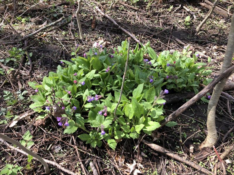
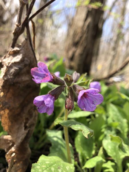
Souharissen Natural Area is covered by riparian deciduous forests growing - borders Grindstone Creek. Canopy trees include species such as Manitoba maple, sugar maple, Norway maple, green ash, white cedar, and black walnut. Vegetation in the subcanopy tree and shrub layer include a mixture of native and exotic, aggressive species, such as buckthorn, multiflora rose, white hawthorn, young trembling aspen and black locust, Tartarian honeysuckle, raspberry, European privet, chokecherry, and red osier dogwood. The forest floor is composed of a mix of native forest and field species, like Jack-in-the-pulpit, fleabanes, Virginia creeper, lady's thumb, Canada goldenrod, trout lily, wood sorrel, and swamp smartweed. However, this environment has also seen the proliferation of weedy exotic species such as garlic mustard, burdock, smooth brome, wild carrot, St. John's wort, black medic, plantain, lungwort, dandelion, and teasel.
In 2005, an archaeological excavation in an old farm field in Waterdown, conducted in advance of the construction of new housing subdivisions, revealed 104 Indigenous archaeological sites in this area that date from 9000 to 3000 BCE. Nearby archaeological sites, which are primarily situated on sandy knolls above Grindstone Creek, have been dated throughout the Archaic and Woodland periods (8000 to 1000 BC, and 1000 CE to the present), providing evidence of long and continued Indigenous habitation of the Grindstone Creek watershed.
Prior to the 1650s, the area around Waterdown was homeland to the Attawandaron or Neutral Nation. Remnants of old trail networks established by the Attawandaron, which were used to traverse from the Niagara escarpment to Lake Ontario, are still preserved in the routes of modern roads like Snake Road and Old Waterdown Road. During the early 1600s, the Attawandaron Nation was led by a chief called Tsouharissen or Souharissen, after whom the Souharissen Natural Area is named. The capital of the Neutral Nation at this time, Ounontisaston, was located in the vicinity of Hamilton Harbor. Souharissen was chief of 28 villages of the Neutral Confederacy, at least from 1626 to around 1646, when he passed away. At that time, the Neutral nation was estimated to have a population ranging from 20,000 to 40,000. However, the Beaver Wars and infectious diseases such as smallpox and cholera that were introduced by European explorers, in combination with famine, were extreme social and environmental stresses that resulted in the loss of nearly half of Attawandaron people. After Souharissen passed away, in 1647, the Neutral Nation was involved in conflict with the Seneca Nation. At this point, due to prolonged conflict and deadly infectious disease, they were only able to muster 1,600 warriors to defend their homelands, a fraction of the 5,000-6,000 warriors who once defended their homelands. The Attawandaron Nation disbursed politically by 1653; many surviving families remained in their ancestral homelands or their members joined into other nations, such as the Seneca Nation or other Indigenous communities.
During the second half of the 17th Century, the Haudenosaunee expanded north, west, and south from their homelands to the east of Lake Erie and South of Lake Ontario. This was to have access to an ever-larger area from which to harvest Beavers, and to be able to trade directly with European settlers, without having to have other Nations as intermediaries. The Nanfanc Treaty of 1701, which was concluded with the British crown and recognized Haudenosaunee expansion, recognizes the larger area of their expansive hunting territories. Over the course of the 18th Century, Neutral homelands became home to the Mississauga Nation, as well as other nations and members of nations who moved for political asylum from intense colonization and European settlement in their homelands, such as the Delaware, Munsee, Tutelo, Meskwaki, and Wampanoag peoples. In Waterdown, there are records of at least two Mississauga communities that developed in the 1700s. Historian Beth Ryan has mapped forty-one Haudenosaunee, Delaware/Munsee, Mississauga and Meskwaki Villages that in 17090, after the American War of Independence/ American Revolution, were located along the Grand River, Tonawanda Creek, Niagara River, Buffalo Creek, Cattaraugus Creek, Genessee River, Alleghany River, and south of Lake Erie. As well, after the end of the American War of Independence, thousands of United Empire loyalists fled to Upper Canada (current-day Southern and Eastern Ontario), including the Mohawks and their Haudenosaunee allies who fought alongside the British. In 1784, the British colonial authority purchased a large tract of land between Lake Ontario, the Niagara River, and Lake Erie from the Mississauga of the Credit First Nation for 1180 pounds. This was called the Between the Lakes purchase. After this exchange, British authorities granted parcels of land to settlers of European origin, as well as the Haldimand Tract to the Mohawks and their Haudenosaunee allies.
The first European settlers of Waterdown began constructing residences by Grindstone Creek by 1802. Early settlements centered around the numerous lumber mills and sawmills that operated on Grindstone Creek. The strong flow of the Grindstone Creek down the Niagara Escarpment near Smokey Hollow provided energy for the operation of these mills, which facilitated the extensive logging of the area during the 1800s.
Souharissen Natural Area was created in response to archaeological excavations and insights achieved in 2005, to honor the Indigenous history and cultural heritage of Waterdown. Souharissen Natural Area was officially established in 2014 through a dedication ceremony. This event included the lighting of a sacred fire at sunrise by Elder Garry Sault of the Mississauga of the Credit First Nation. Throughout the day, the fire was kept burning by a Firekeeper from Six Nations of the Grand River. Since then, Souharissen Natural Area has become a space for land-based learning, where local students and residents have conducted various natural and cultural heritage revitalization projects. In 2018, the site of the sacred fire was marked with a monument stone and the planting of a medicine garden. Mississauga of the Credit First Nation gifted plants for a medicine garden that was planted within a canoe that was donated by a local resident. Furthermore, local students planted tree saplings and constructed a garden dedicated to the survivors and children lost to the residential school system. Finally in 2020, elementary and high school students set up seven bat-houses, which they painted with motifs representing the Anishinaabe Seven Grandfather Teachings.
“The Souharissen Natural Area Waterdown, Ontario, On the Treaty territory of the Mississaugas of the Credit, as well as lands used by the Neutral Nation, Haudenosaunee Confederacy and Wendat Confederacy,” Souharissen Natural Area, Waterdown - Mr.Tidridge's Website
Ryan, Beth. 2017. “Crowding the Banks: The Historical Archaeology of Ohagi and the Post-Revolutionary Haudenosaunee Confederacy, ca. 1780 - 1826.” A dissertation found online through creative commons at: https://ecommons.cornell.edu/items/482176aa-1a74-46f0-a582-323b73b047ba
| English | Latin | Kanienʼkéha | Anishinaabemowin |
|---|---|---|---|
| Green Ash | Fraxinus pennsylvanica | kaneróhon | emikwaansaak, aagimaak, bwoyaak |
| Staghorn Sumac | Rhus typhina | tará:kwi | paakwan, baakwaanaatik, baakwaanmizh, ma'kibag, kaagaag-miin-gaawahnshiik |
| White Cedar | Thuja occidentalis | onen’takwehtèn:tshera | giizhigaa'aandak, giizhik |
| Manitoba Maple | Acer negundo | kahwisto’kéha wáhta | adjagobi’mak |
| Sugar Maple | Acer saccharum | wáhta’, ohwáhta | ininaatik, ininaatig (-oog, plural) |
| Burdock | Arctium lappa | ohrohte’kó:wa | zagdebwe, zadebwe |
| Jack-in-the-pulpit | Arisaema triphyllum | tyehnónhserote, kyehnónserote, kárhon, tsyorákares, tsorákares, kahnéhserote, okwá:rot nikarhonksherá:'a | zhaashaagomin |
| Red Osier Dogwood | Cornus sericea | onekwén:tara niwatahtsherò:ten, o’seranekwénhtonh, watatshero:'ten, onekwénhtara niwatatsherò:ten | miskwabi 'mik, mskwabiimnagohns, miskwaabiimizh "red shrub" Cornus sericea |
| White Hawthorn | Crataegus punctata | ohì:kta wahyarà:ken; yotironhwentsí:yo | miinensgaawanzh |
| Wild Carrot | Daucus carota | anonhsanónhna, watatewenní:yo otsíhkwa | kaadaakoon |
| Trout Lily | Erythronium americanum | skatsihstóhkonte | namegbagoniin |
| Green Ash | Fraxinus pennsylvanica | kaneróhon | emikwaansaak, aagimaak, bwoyaak |
| Black Walnut | Juglans nigra | tsyohsò:kwak | bagaanaak |
| Common Yellow Woodsorrel | Oxalis stricta | teyoratu teyorá:ton | ziiwanabagashk |
| Virginia Creeper | Parthenocissus quinquefolia | kontiráthens | mnidoo- biimaakwad bebaamooded |
| Smartweed | Persicaria virginiana | aweryahsarónyon, tyononhkwà:tsheros | ojig'imin |
| Ribwort Plantain | Plantago lanceolata | atenhnéha, teyohahó:ron | onaanigizidaanbag (-oon, plural), ginebigowashk, mashkiigobag, omakakiibag |
| Common plantain | Plantago major | atenhnéha, teyohahó:ron | onaanigizidaanbag (-oon, plural), ginebigowashk, mashkiigobag, omakakiibag |
| Swamp Smartweed | Polygonum hydropiperoides | aweryahsarónyon, tyononhkwà:tsheros | ojig'imin |
| Trembling Aspen | Populus tremuloides | onerahtón:ta, o’nerahtón:ta, orahaton takorokwa | azaadi, azaadiins, azaadiins, azaadiig, zaad, zaat |
| Black Cherry | Prunus serotina | é:ri, e:ri’kó:wa, tyotyò:ren | ookweminagaawanzh, ookweminan, ikwe'mic |
| Chokecherry | Prunus virginiana | tyakonya’tawén:’eks, teyakonya’tawén:’eks | asasaweminagaawanzh, asasaweminan, baakinminaan, asasaweminogaawangh |
| Staghorn Sumac | Rhus typhina | tará:kwi | paakwan, baakwaanaatik, baakwaanmizh, ma'kibag, kaagaag-miin-gaawahnshiik |
| Red Raspberry | Rubus idaeus | skanekwen’terá:yen, skanekwen’terá:ne, skanekwenhtará:nenh | miskomin (-ak, plural) |
| Canada Goldenrod | Solidago canadensis | otsí:nekwar niyotsi’tsyò:ten | ajidamoowaanow, waabanoominens/waabanoominensag, giizisso mashkiaki |
| Dandelion | Taraxacum officinale | tekaronhyaká:nere | mindemoyanag, doodooshaaboojiibik, mindimooyenh, wezaawaaskwaneg |
| White Cedar | Thuja occidentalis | onen’takwehtèn:tshera | giizhigaa'aandak, giizhik |
| Wild Grape | Vitis riparia | o’nénhare | zhoominan, jo’minaga’wanj |