Manoomin Gamii / Michisaagiig of Rice Lake
Location
GPS Coordinates
Rice Lake Conservation Area is a 73.7 hectare forested natural area located on the southern tip of Rice Lake, which is a warm shallow lake. The name Rice Lake is reflective of the native species of grass, wild rice, that once grew abundantly on the lake margins. The Conservation Area is currently managed by the Ganaraska Region Conservation Authority and can be accessed through 2.6 kilomters of trail that traverses to the shore of Rice Lake.
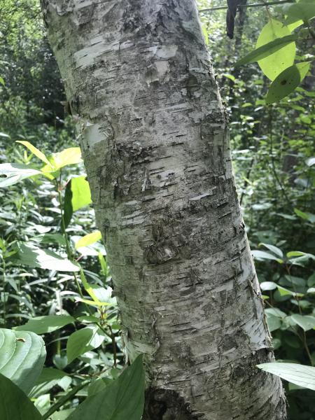
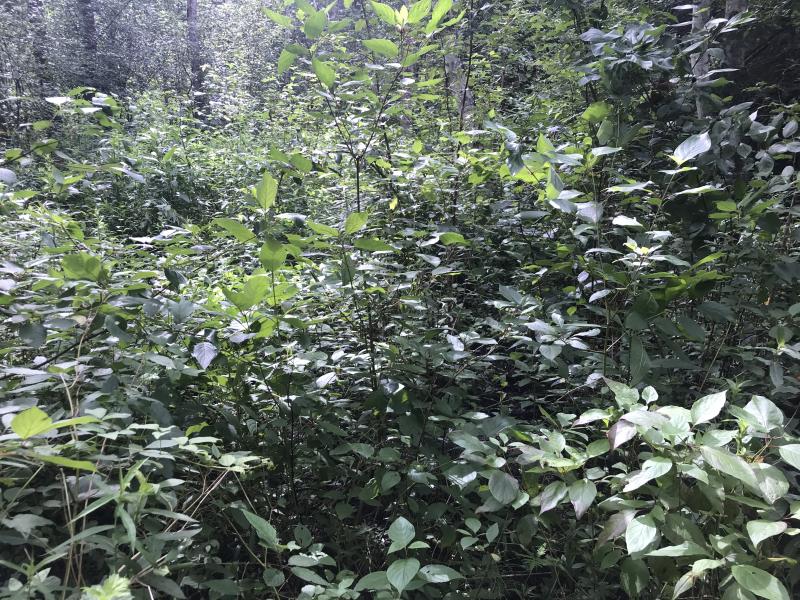
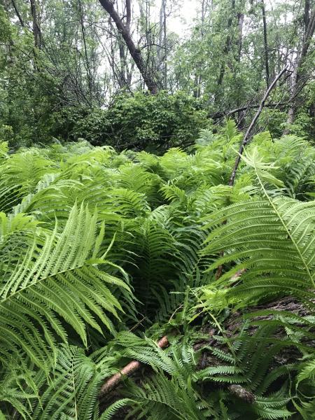
Rice Lake Conservation Area is composed mainly of deciduous swamps with canopy dominants of white birch, bitternut hickory, red oak, and red maple, growing in association with white spruce, burr oak, and green ash. Smaller trees and shrubs that grow under the canopy include chokecherry, alternate dogwood, swamp oak, raspberry, and grapevine. The swamp floor is mostly composed of ostrich fern and sensitive fern, with associates of lady fern, Canada avens, false Solomon's seal, wood sorrel, and horsetails.
The southeast side of Rice Lake, which is composed of dry, sandy hills, supports remnants of tall grass prairie ecosystems, which were once expansive throughout southern Ontario. These prairies are characterized by black and white oak growing scattered among native grasses including big bluestem, Indian grass, and switchgrass. Wildflowers are also abundant in tallgrass prairies, and include species such as prairie smoke, Seneca snakeroot, smooth rose, wild bergamot, New Jersey tea, and butterfly milkweed.
The shores of Rice Lake are rich in archaeological significance, with numerous sites having been excavated that span the entire Holocene. Among them, the oldest village site is located on the north shore of the lake, and dates to approximately 9000 BCE. Another village site, which archaeologists call the McIntyre site, is also located on the north shore, near the mouth of the Indian River. It was occupied from the early Paleo-Indian period (10 000 BCE to 8000 BCE) through the late Archaic period (1000 to 500 BCE). Clusters of Paleo-Indian and early Archaic (8000-6000 BCE) sites have also been documented on the south-western shore.
The most significant archaeological structures in the Rice Lake vicinity are the Serpent and Egg mounds. These are a cluster of nine burial mounds that are associated with the Princess Point culture and early Iroquoian cultures, who are the ancestors of modern Iroquoian nations, including the Huron-Wendat, Attiwandaron/Neutral, Tionontati/PetunTobacco, and Haudenosaunee. These mounds are located on a promontory on the north shore of Rice Lake at the eastern mouth of the Indian River, which is called Roach’s Point. The largest of the nine mounds is formed in the shape of a serpent, 60 meters in length, with a height ranging from 1.5 to 1.8 meters and a width of 8 meters, and with undulations occurring every 12 meters. The ‘serpent’ is oriented in a northeastern direction, and burials are concentrated at six points along its length. A further eight small, round mounds, which are likened to serpent eggs, surround the serpent. An associated village site is located 70 meters southwest of the Serpent Mound cluster.
The midden associated with the settlement site has been dated to 50 BCE to 300 CE, and the midden contents reveal a rich array of food sources that the inhabitants incorporated into their diets. The people who lived at the Serpent Mound site practiced a hunting, fishing, and harvesting way of life. The most important dietary component was shellfish, but other animal species, including cervids, canids, foxes, bears, birds and waterfowl, amphibians, reptiles, and fish were also consumed. The mounds are dated from 130 - 300 CE, with two burial layers. In the older burial layer, skeletons were found in a sitting position. In comparison, skeletons from the more recent burial layer were found positioned with their knees drawn up to their chins. Burials are often accompanied by grave goods, such as shells, carvings, and tools.
Rice Lake continued to be an important Indigenous homeland from 800 CE to 1250, which is evidenced by the findings of Iroquoian camps on the north shore of the Lake. Furthermore, Rice Lake Conservation Area is situated at the northern terminus of the Ganaraska Portage, which is a 16-kilometer Indigenous trail connecting the north shore of Lake Ontario, near modern-day Port Hope, to Rice Lake. The Ganaraska Portage was extensively used by the Huron-Wendat Nation, who lived in the region from 1000-1550 CE. The Huron-Wendat Nation relocated to their current location of Wendake around 1650, during the Beaver Wars, which was a period of armed conflict between the Huron-Wendat with their Indigenous and French allies, and the Haudenosaunee Confederacy with their English and Dutch Allies. Members of the Haudenosaunee Confederacy, including the Cayuga and Mohawk nations, established settlements along the Ganaraska portage. For example, in 1668, a Jesuit mission called Ganaraske was founded at the southern end of the Portage and is the namesake for Ganaraska.
After the 1701 Great Peace of Montréal/ La Paix des Braves, Haudenosaunee peoples moved back south of Lake Ontario, and the Ganaraska region was resettled by the Mississauga peoples, who came from their previous homelands on the north shore of Lake Huron and Manitoulin Island. Throughout the 1700s, the Mississaugas maintained a seasonal lifestyle and food system of hunting, fishing and gathering, and continued to use the Ganaraska portage to move between Lake Ontario and Rice Lake. Rice Lake was an especially important location for the gathering of wild rice, which was and is a staple in the diets of Anishinaabe. The Mississaugas also carried out cultural burning on the Rice Lake Plains to caretake and maintain tallgrass prairie ecosystems, which were important hunting grounds.
During this time, the Ganaraska Portage played a crucial role in facilitating fur trade, in which the Mississauga peoples were expert participants. However, in 1783, following the American War of Independence/ Revolutionary War, several thousand United Empire Loyalists fled to Upper Canada, and the British colonial authority signed a series of treaties with various Indigenous nations to obtain land for settlers and Indigenous peoples who had fought as allies of the British. In 1783-1784, they signed the Crawford purchase with the Rice Lake Mississaugas (currently Hiawatha First Nations), which saw the exchange of a large swath of land from the eastern end of Lake Ontario to the northern shore of the St. Lawrence River. In 1818, the British Crown signed Treaty 20, also known as the Rice Lake Purchase, with several Mississauga nations, which created an agreement for British and other Europeans to settle in the Kawarthas region. Finally in 1923, the British Crown signed the Williams Treaties with seven Anishinaabe nations, which the British Crown interpreted as a transfer of a large tract of land in south central Ontario to the Crown.
The British Crown surveyed the shore of Rice Lake from 1795-1796, and distributed land parcels to loyalists shortly thereafter, facilitating the start of European settlement in the area. In 1838, they constructed the Trent-Severn Waterway, which was a system of canals linking Lake Ontario to Georgian Bay via a series of rivers and lakes through the Quinte and Kawartha regions, which created the results of fluctuating water levels across the Kawartha region lakes. Rice Lake experienced a 1.8-meter water level rise, which drowned the wild rice beds. The introduction of the Asian carp in the 1870s and a hurricane in 1928 caused further damage to the rice beds. By the 1950s, wild rice in Rice Lake had been completely eradicated, although it is always possible to create projects to restore locally-eradicated species.
Today, the original Ganaraska Portage no longer exists in its entirety. Parts of it have been replaced by roads such as Ontario Street in Port Hope and Highway 28. The shores of Rice Lake continue to be Anishinaabe homelands, with Hiawatha First Nation on the north shore, and Alderville First Nation on the southeast shore near Roseneath. These First Nations continue to steward the natural and cultural heritage of the region. For example, in a collaborative effort with settler governments and environmental non-profit organizations, Alderville First Nation is actively engaged in restoring tallgrass prairies by planting native species and returning Indigenous cultural burning to the land. The Serpent Mounds are currently cared for by Hiawatha First Nation.
Alderville First Nation: https://alderville.ca/
Ganarska Conservation Areas: Conservation Areas | GRCA
Michisaagiig of Hiawatha First Nation: https://www.hiawathafirstnation.com/
The Rice Lake Plains Partnership: Alderville First Nation, the County of Northumberland, Ganaraska Region Conservation Authority, Lower Trent Region Conservation Authority, the Nature Conservancy of Canada, Northumberland Land Trust and Ontario Parks: Rice Lake Plains Partnership – Restore. Learn. Protect.
Serpent Mounds Park, Hiawatha First Nation: https://www.hiawathafirstnation.com/business-tourism/serpent-mounds-park/
| English | Latin | Kanienʼkéha | Anishinaabemowin |
|---|---|---|---|
| Bitternut Hickory | Carya cordiformis | o’nón:na, ontsí:kahwe, yohso'kwatskà:rat | mitigwaabaak (-ook, plural) |
| Wild Strawberry | Fragaria virginiana Duchesne | ken’niiohontesha, niyohentéhsha’, niyohontéhsa, ken’niyohontésha | odeimin (-an, plural) |
| Black Ash | Fraxinus nigra | éhsa | baapaagimaak, bwoyaak |
| Green Ash | Fraxinus pennsylvanica | kaneróhon | emikwaansaak, aagimaak, bwoyaak |
| Staghorn Sumac | Rhus typhina | tará:kwi | paakwan, baakwaanaatik, baakwaanmizh, ma'kibag, kaagaag-miin-gaawahnshiik |
| Red Maple | Acer rubrum | ka’takén:ra | zhiigmewanzh, zhiishiigimiiwanzh (-iik, plural) |
| Yarrow | Achillea millefolium | aró:sen raotáhson, skaweró:wane aotihonte | ajidamoowaanow, a'djidamo'wano |
| Common Ragweed | Ambrosia artemisiifolia | skawiró:ne, skaweró:wane | (check this) |
| Lady Fern | Athyrium felix-femina | yetskarónhkwa | a' sawan, naanaaganashk (-oon), mzise miijim |
| Paper birch | Betula papyrifera | watenakè:taron's, watenakè:taronhs | wiigwas (singular), wiigwaasaatig (plural), wiigwaasi-mitig |
| Bitternut Hickory | Carya cordiformis | o’nón:na, ontsí:kahwe, yohso'kwatskà:rat | mitigwaabaak (-ook, plural) |
| Alternate-leaf Dogwood | Cornus alternifolia | teyotsí:tsayen | moozwemizh, moozomizh, niibiishan miskwaabiimizhiig |
| Gray Dogwood | Cornus racemosa | tsítyete | mazh’omizh |
| Red Osier Dogwood | Cornus sericea | onekwén:tara niwatahtsherò:ten, o’seranekwénhtonh, watatshero:'ten, onekwénhtara niwatatsherò:ten | miskwabi 'mik, mskwabiimnagohns, miskwaabiimizh "red shrub" Cornus sericea |
| Wild Carrot | Daucus carota | anonhsanónhna, watatewenní:yo otsíhkwa | kaadaakoon |
| Field Horsetail | Equisetum arvense | aweyó:ta | aanikawishkoons, zhiishiibinashk |
| Meadow Horsetail | Equisetum pratense | aweyó:ta | aanikawishkoons, zhiishiibinashk |
| Wild Strawberry | Fragaria virginiana Duchesne | ken’niiohontesha, niyohentéhsha’, niyohontéhsa, ken’niyohontésha | odeimin (-an, plural) |
| Black Ash | Fraxinus nigra | éhsa | baapaagimaak, bwoyaak |
| Green Ash | Fraxinus pennsylvanica | kaneróhon | emikwaansaak, aagimaak, bwoyaak |
| False Solomon’s Seal | Maianthemum racemosum | kítkit o'éta | agongseminan, agongosimizh, agong’osiminan |
| Wild Bergamot | Monarda fistulosa | yeton'kwanonhsatáhkwa, iako'tonhkwanóstha, Ie'tonhkwanostáhkhwa | sasap-kwanins, sasaapkwaanins, weca'was wackwi'nek, bibi'gwanakak |
| Sensitive Fern | Onoclea sensibilis | tsyohtehrí:seron | a’nana’ganak, naanaaganashkoon |
| Common Yellow Woodsorrel | Oxalis stricta | teyoratu teyorá:ton | ziiwanabagashk |
| Virginia Creeper | Parthenocissus quinquefolia | kontiráthens | mnidoo- biimaakwad bebaamooded |
| White Spruce | Picea glauca | ohsó:ra onéhta | mina'ig, gaawaandgwaatig, gaa'aandak, gawaandakook, inin'aandakook, gaawaandag |
| Seneca Snakeroot | Polygala senega | (check this) | waansikehnswan, bi'jikiw'ack |
| Black Cherry | Prunus serotina | é:ri, e:ri’kó:wa, tyotyò:ren | ookweminagaawanzh, ookweminan, ikwe'mic |
| Chokecherry | Prunus virginiana | tyakonya’tawén:’eks, teyakonya’tawén:’eks | asasaweminagaawanzh, asasaweminan, baakinminaan, asasaweminogaawangh |
| Burr Oak | Quercus macrocarpa | otokénha | mitigo'mic, bgaak-mizh |
| Red Oak | Quercus rubra | karíhton | miskode-miizhmizh, mitig mewish (-iik plural) |
| Staghorn Sumac | Rhus typhina | tará:kwi | paakwan, baakwaanaatik, baakwaanmizh, ma'kibag, kaagaag-miin-gaawahnshiik |
| Red Raspberry | Rubus idaeus | skanekwen’terá:yen, skanekwen’terá:ne, skanekwenhtará:nenh | miskomin (-ak, plural) |
| Canada Goldenrod | Solidago canadensis | otsí:nekwar niyotsi’tsyò:ten | ajidamoowaanow, waabanoominens/waabanoominensag, giizisso mashkiaki |
| Dandelion | Taraxacum officinale | tekaronhyaká:nere | mindemoyanag, doodooshaaboojiibik, mindimooyenh, wezaawaaskwaneg |
| Poison Ivy | Toxicodendron radicans | yakohón:taras, yakohontaráhstha, wate’nenharì:sere, yakohén:tara’s | nimkiibak |
| Wild Grape | Vitis riparia | o’nénhare | zhoominan, jo’minaga’wanj |
| Tall Thimbleweed | Anemone virginiana | anihsnonhsó:roks | (check this) |
| Ostrich Fern | Matteuccia struthiopteris | kahtehrahòn:tsi | zhishkwedaansan, naanaaganashk (-oon) (general name for ferns), mzise miijim (general term for fern) |
| Evening Primrose | Oenothera biennis | yakosá:tens onawí:ra | (check this) |
| Smooth Rose | Rosa blanda | oginiiwaatik, gaawaak-bagoohnseak | |
| Mullein | Verbascum thapsus | kén:reks aotahsa, ótkon raoyèn:kwa, karisé:, ótkon oyén:kwa | o'makiki'bag |