Yotstenhrakè:ron “Spread out Stone”
Naadwe- zaagiing Aazhbikoon
Location
GPS Coordinates
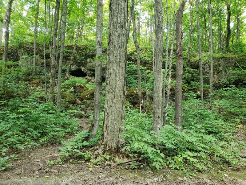
Nottawasaga Bluffs is a 160-hectare conservation area in Simcoe County, south of Georgian Bay, and is managed by the Nottawasaga Valley Conservation authority. Located on the Blue Mountain section of the Niagara Escarpment, Nottawasaga Bluffs is best known for a variety of geological formations associated with the escarpment, such as tall cliffs, caves and crevices, rolling hills, and 30 m tall rock bluffs, which give the conservation area its name. A network of trails, including the Bruce trail, provides access to the natural environments in the conservation area and to several look-out points.
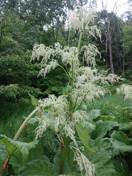
Nottawasaga Bluffs is composed of sugar maple dominant patches of deciduous and mixed wood forests typical of the Great-Lakes-St. Lawrence Forest region. In these forest types, sugar maple form the most numerous component of the canopy, interspersed with species such as green ash, slippery elm, black cherry, and, in the mixed-wood portions, eastern white cedar and balsam fir. Common understory shrubs include alternate-leaved dogwood, currants, chokecherry, blackberry, and spreading dogbane. The forest floor is home to a diversity of herbaceous species, such as enchanter’s nightshade, Canada violet, Jack-in-the-pulpit, agrimony, starry Solomon’s seal, Canada mayflower, asters, baneberries, hepaticas, blue cohosh, and ramps.
Archaeologists have thus far characterized human habitation of the southern Georgian Bay area as being heavily influenced by post-glacial fluctuations of lake water levels, over the last 5000 years, and instability in stream flow of the Nottawasaga River. Following the end of the last Ice Age, what is today called Simcoe County was submerged underneath glacial Lake Algonquian, whose shoreline extended south of present-day Lake Simcoe. From 8000 to 10 000 years ago, the area experienced a low water period, followed by a high-water period peaking at 5500 years ago, which was also when the channel of the Nottawasaga River stabilized. Modern lake levels settled around 2800-4500 years ago.
Archaeological evidence of human habitation of the region derives from what archaeologists call the Paleoindian period, which they date back to 9000-11 000 BC. The most significant archaeological excavation from that time period in this area is what archaeologists named the Fisher site, which is located on high ground near the shoreline of Georgian Bay and consists of more than 2600 pieces of stone tools, including 156 fluted points, and 36 types of chert faces. Archaeologists associate the findings at this site with what they have characterized as the “Parkhill cultural complex,” based upon the stone tool technology they have found from that time period. There is also archaeological evidence of clusters of camps in upstream areas of the Nottawasaga River basin, which date to the Archaic period, 5500 years ago. Archaeological evidence also shows that gradually, over time, camps moved further downstream and along the Georgian Bay shoreline.
The Archaic and early Woodland era occupants of Simcoe County were Algonquian speaking peoples who followed seasonal settlement rotation lifeways that were primarily dependent upon hunting and gathering food systems. Iroquoian speaking peoples moved to Simcoe County during the middle Woodland period. They likely moved north from the shores of Lake Ontario following rivers and the Niagara escarpment, first arriving in current-day Nottawasaga Township, and then moving east to the shores of Lake Simcoe and modern-day Barrie. These migration patterns are speculated upon by archaeologists based upon the material record, but it would be important to integrate oral history from Iroquoian and Algonquian peoples about their long-term history in the region – which we have not done yet and is a critical area for future inquiry.
Archaeological records dating from prior to the 1200s in Simcoe County have thus far been interpreted as Iroquoian small-scale villages that followed a pattern of seasonal occupation, supporting hunting, fishing and trading with Algonquian peoples. The archaeological record shows larger Iroquoian villages being established there between the 1200s to 1500s. There has often been a tendency to interpret material evidence of larger villages as more “permanent,” and of smaller dwellings as “seasonal,” but Indigenous studies scholars are contributing new perspectives, suggesting permanence cannot necessarily be inferred from the size of community or dwelling or extent of material record in the environment. Many Indigenous peoples lived in decentralized kinship groups who moved with the seasons between established and familiar sites that they knew well; movement and small-scale communities made for more dispersed materials in the archaeological record across their homelands. Indigenous peoples even moved larger villages (such as villages of longhouses) that have been often characterized as “permanent” settlements when the immediate environs became depleted from hunting, fishing and the soil needed to lay fallow from farming. These practices were environmental sustainability and food systems methodologies to ensure that farming and food harvest were abundant in the village environs – the philosophy of which is demonstrated in the One Dish, One Spoon or Dish With One Spoon wampum agreement made between Iroquoian and Algonquian peoples. Archaeologists characterize the larger villages that were built during the time period of the 13th through the 16th Centuries by the presence of longhouses and an abundance of pottery, and estimate that they housed several hundred people.
During the 1500s, networks of villages in the region were associated with the Tionontati (Petun or Tobacco peoples). These villages were connected by well-used trails, and surrounded by agricultural fields consisting of rows of corn mounds. The Sidey-Mackey and Melville sites in Creemore that date to the 1580s are some of the most well-researched Tionontati villages from this time period. Relations between the Tionontati and Algonquians during this period were alliances – but this political history is another that should be further documented from the perspectives of the Algonquian descendants who live there today. While Tionontati developed permanent settlement networks, Algonquian kin and hunting groups who were traveling for hunting and trade often overwintered in Tionontati villages. In addition, findings of chert originating from Northern Ontario have been found in Tionontati villages which archaeologists regard as evidence of trade between these two cultures. In the late 1500s, the Haudenosaunee Confederacy “dispersed” the Tionontati from Simcoe County when they moved into the Nottawasaga river valley where they lived during the 17th century. The Haudenosaunee probably moved there due to their involvement in the beaver trade; again, oral history will be the most reliable source for understanding what happened to the Tionontati peoples who lived there, whether they were adopted or forced to migrate elsewhere. The Haudenosaunee left this village area in the early 1700s, after which Ojibwe families moved to Simcoe County in greater numbers, becoming the largest Indigenous people in the area. Ojibwe representatives signed Treaty 18 with the British Crown in 1818, their perspective and interpretation of which is another necessary area of inquiry for scholarship. The British Crown interpreted this treaty as “opening up the area for settlement,” and they first surveyed what they ended up calling Nottawasaga township in 1832-1833. European settlers first built their villages around sawmills on the nearby Mad River in the 1840s.
ASI Research: “A Detailed Ceramic Analysis and Excavation History of the Sidey-Mackey Site”: https://asiheritage.ca/we-are-sharing-our-research/
Nottawasaga Valley Conservation Area: CA - Nottawasaga Bluffs - NVCA
| English | Latin | Kanienʼkéha | Anishinaabemowin |
|---|---|---|---|
| Green Ash | Fraxinus pennsylvanica | kaneróhon | emikwaansaak, aagimaak, bwoyaak |
| Balsam Fir | Abies balsamea | otshohkó:ton | zhingop |
| Sugar Maple | Acer saccharum | wáhta’, ohwáhta | ininaatik, ininaatig (-oog, plural) |
| White Baneberry | Actaea pachypoda | onekwénhtara niwahyò:ten, orá:tu | wiikizigan, wapkadak |
| Red Baneberry | Actaea rubra | onekwénhtara niwahyò:ten, orá:tu | memskwagenagodeg, wi’cosidji’bik |
| Wild Leeks | Allium tricoccum | o'nyónkseri | bgoji-zhi, agaagawinzh (-iig, plural), siga'gawanj, siga'gawanch |
| Spreading Dogbane | Apocynum androsaemifolium | wahseriye'tonnyà:tha, skatsí:wa'k | sasa'bikwan, ma'kwona'gicobji'bik |
| Jack-in-the-pulpit | Arisaema triphyllum | tyehnónhserote, kyehnónserote, kárhon, tsyorákares, tsorákares, kahnéhserote, okwá:rot nikarhonksherá:'a | zhaashaagomin |
| Blue Cohosh | Caulophyllum thalictroides | karhakón:ha, kahrhatakon | kwemshkiki, be'cigodji'bigak, bezhigojiibik, zhiigimewibag |
| Wild Basil | Clinopodium vulgare | (check this) | (check this) |
| Alternate-leaf Dogwood | Cornus alternifolia | teyotsí:tsayen | moozwemizh, moozomizh, niibiishan miskwaabiimizhiig |
| Gray Dogwood | Cornus racemosa | tsítyete | mazh’omizh |
| Bulblet Bladder Fern | Cystopteris bulbifera | (check this) | naanaaganashk (-oon), mzise miijim |
| Fragile Fern | Cystopteris fragilis | (check this) | naanaaganashk (-oon), mzise miijim |
| Meadow Horsetail | Equisetum pratense | aweyó:ta | aanikawishkoons, zhiishiibinashk |
| Green Ash | Fraxinus pennsylvanica | kaneróhon | emikwaansaak, aagimaak, bwoyaak |
| White avens | Geum canadense | (check this) | nebonea'bkweag |
| Sharp-lobed Hepatica | Hepatica acutiloba | kontirontá:non, karón:tanonhne | gabisan’ikeag, a'nima'sid |
| Canada Mayflower | Maianthemum canadense | (check this) | agongosi’minan (-ak, plural) |
| Crab Apple | Malus sylvestris | sewahyó:waneh | mishiiminaatik, mishiiminaatig |
| Common Yellow Woodsorrel | Oxalis stricta | teyoratu teyorá:ton | ziiwanabagashk |
| Virginia Creeper | Parthenocissus quinquefolia | kontiráthens | mnidoo- biimaakwad bebaamooded |
| White Spruce | Picea glauca | ohsó:ra onéhta | mina'ig, gaawaandgwaatig, gaa'aandak, gawaandakook, inin'aandakook, gaawaandag |
| Heal-all | Prunella vulgaris | yako'nikonrákhas onónhkwa, katsitsoró:kon | ingijibinaa, ogijibinaan, basi’bagak |
| Chokecherry | Prunus virginiana | tyakonya’tawén:’eks, teyakonya’tawén:’eks | asasaweminagaawanzh, asasaweminan, baakinminaan, asasaweminogaawangh |
| Black Cherry | Prunus serotina | é:ri, e:ri’kó:wa, tyotyò:ren | ookweminagaawanzh, ookweminan, ikwe'mic |
| Skunk Currant | Ribes glandulosum | nikanenharà:sa | mieidji’minaga’wanjiig, waaboos-odji-bik , gaagaagshiinh miinan |
| Black Swamp Gooseberry | Ribes lacustre | tyorenatsí:yo, ohrá:ton, anáduma:o:náhi | zhaabo-miinashkoon, zhaaboomin (-aak, plural), me’skwacabo’minak, kaawe-saba |
| Blue Wood-aster | Symphyotrichum cordifolium | teyonerahtawe'éhston, yotsiron’onhkóhare orón:ya | naskosi'icus |
| White Panicled Aster | Symphyotrichum lanceolatum | yako’tonhkwárhos onónhkwa | name'gosiibag |
| Calico Aster | Symphyotrichum lateriflorum | teyonerahtawe'éhston, yotsiron’onhkóhare orón:ya | name'gosiibag |
| Arrowleaf Aster | Symphyotrichum urophyllum | yako’tonhkwárhos onónhkwa | name'gosiibag |
| Dandelion | Taraxacum officinale | tekaronhyaká:nere | mindemoyanag, doodooshaaboojiibik, mindimooyenh, wezaawaaskwaneg |
| White Cedar | Thuja occidentalis | onen’takwehtèn:tshera | giizhigaa'aandak, giizhik |
| Slippery Elm | Ulmus rubra | akará:tsi | ozhaashigob |
| White Violet | Viola canadensis | tekonnyarotárhoks, tekonteniarotáhrhoks, tewatenyarotárhos | maskwi’widzhi’wiko’kok |
| Wild Grape | Vitis riparia | o’nénhare | zhoominan, jo’minaga’wanj |